Mt. Lemmon Infrared Observatory -- Altitude 2800 m (9157 feet)
 The Mt. Lemmon Infrared Observatory site
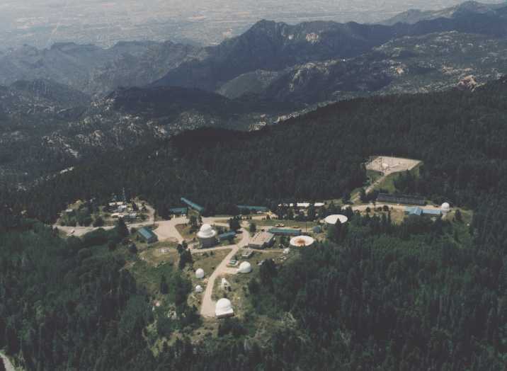
An aerial view of the summit of Mt. Lemmon. This "sky island" is located approximately 45 miles north of the University of Arizona in the Coronado National Forest in the Catalina mountains. In this view looking south towards Tucson, the 60-inch telescope is at the extreme bottom center and the 40-inch telescope is above it to the right of the road. The men's and women's dormitories are the long, darkish buildings near the top center. Further to the right is the Learning Center of the Mt. Lemmon SkyCenter, a year-long educational offshoot of Astronomy Camp. At the extreme right center is another 60-inch telescope operated by the University of Minnesota. This telescope played a a fundamental role in the development of infrared astronomy. In the building adjacent to that telescope dome, there is a half-court gymnasium for lectures, demos, and recreation. Most of the camp activities, including meals, take place in the Minnesota and SkyCenter facilities.
This 20-acre site has played a historic role in the defense of our country and in the development of infrared astronomy. It was formerly a Radar Base of the Air Defense Command and was converted into an observatory for infrared astronomy in October 1970. Until 2003, a geodesic dome near the left center of the aerial view housed the last of the radar tracking facilities which was operated by Ft. Huachuca. This station was also able to direct the Space Shuttle to an emergency landing in White Sands, New Mexico and was involved with initial testing of cruise missile navigation. The square area at top right is a former communications center for the Titan m issile defense system. Further information and interesting photos about the role of Mt. Lemmon and the Air Defense Command can be found in the Arizona Daily Star and at Air Defense Radar Veterans' Assoc. (select "Radar Museum," then "Radar Sites," and search for the location of "Lemmon.")
The summit area itself is Federal land and is maintained by the University for astronomical research and science education under the terms of a Permit with the U.S. Forest Service. The site operates on commercial electrical power with its own standby power plant. Water is obtained from several deep wells and stored in 500,000-gal. tanks (right center). A full-time supervisor resides at the site. Emergency medical personnel are based only three miles away and a helicopter landing area is available (left of geodesic dome) for emergencies.
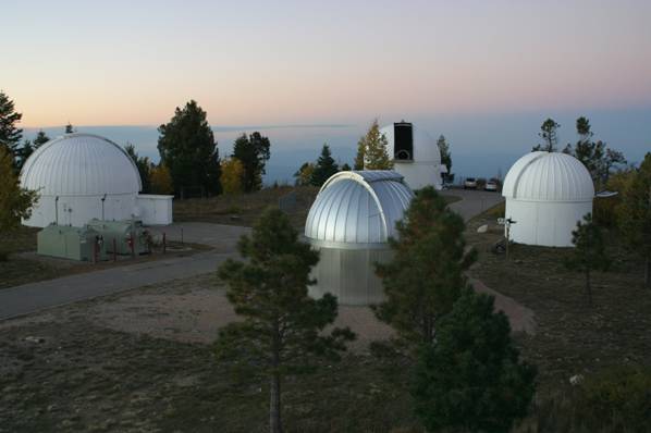
The 24-inch (Phillips) and 32-inch (Schulman) reflectors
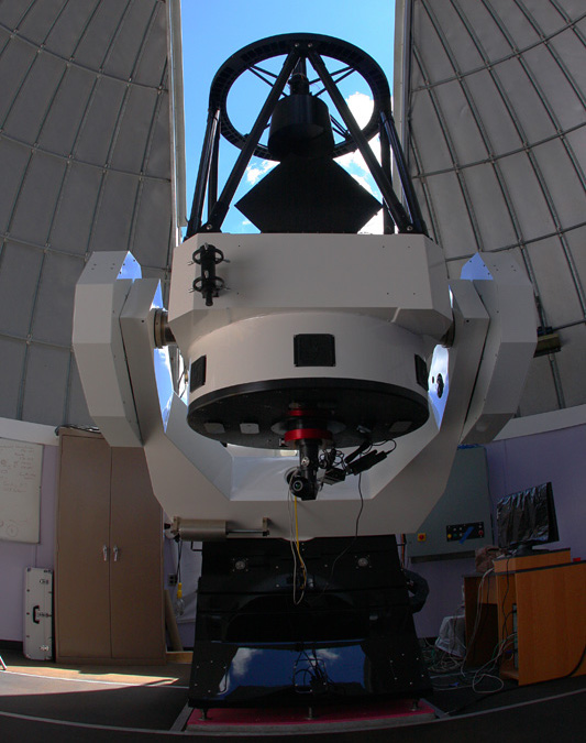 These modern telescopes are a featured attraction of the public programs of the Mt. Lemmon SkyCenter.
These new telescopes displaced the 20-inch Jamieson and historic 40-inch telescopes which are described below.
These modern telescopes are a featured attraction of the public programs of the Mt. Lemmon SkyCenter.
These new telescopes displaced the 20-inch Jamieson and historic 40-inch telescopes which are described below.
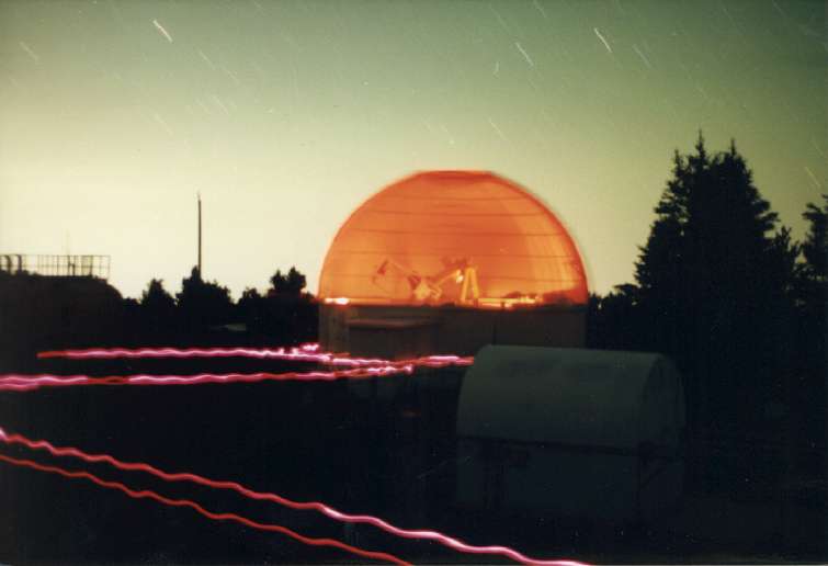
The 60-inch Cassegrain reflector of the Mt. Lemmon Observing Facility (MLOF)
This f/15 infrared-optimized telescope played a fundamental role in the pioneering developments of infrared astronomy in the 1970's and is still operated by the Universities of Minnesota and Arizona. During that time, the summit of Mt. Lemmon was the highest altitude, continental site for infrared astronomy. Advanced Astronomy Campers use the 2MASS camera for infrared imaging observations in the so-called J,H,K wavelengths bands in the near-infrared spectrum.
The 60-inch Cassegrain reflector - Catalina Sky Survey
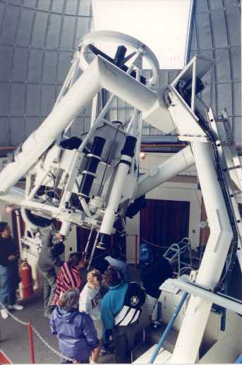 The 60-inch Cassegrain reflector incorporates a parabolic primary mirror (f/2) with interchangeable secondaries to achieve Cassegrain focal
ratios of either f/16 or f/45. The telescope can also be used at prime focus where a CCD-mosaic camera which captures images of a one degree
wide field-of-view down to magnitude 22. This camera is used routinely by the Catalina Sky Survey
to discover and monitor near-earth asteroids and minor planets in the solar system. The latter is used for infrared observations. The telescope
has a motorized equatorial mount equipped accurate encoders for positioning on the sky. An adjacent warm room is used by Astronomy Campers to
analyze their data by computer image processing and to plan the details of their observations.
Click here for more information about the 60-inch telescope.
The 60-inch Cassegrain reflector incorporates a parabolic primary mirror (f/2) with interchangeable secondaries to achieve Cassegrain focal
ratios of either f/16 or f/45. The telescope can also be used at prime focus where a CCD-mosaic camera which captures images of a one degree
wide field-of-view down to magnitude 22. This camera is used routinely by the Catalina Sky Survey
to discover and monitor near-earth asteroids and minor planets in the solar system. The latter is used for infrared observations. The telescope
has a motorized equatorial mount equipped accurate encoders for positioning on the sky. An adjacent warm room is used by Astronomy Campers to
analyze their data by computer image processing and to plan the details of their observations.
Click here for more information about the 60-inch telescope.
Both the former 40- and 60-inch telescopes were developed "in-house" at the Lunar and Planetary Laboratory's optics shop by optician Mr. Robbie Wayland. They are described in his book "Optics of the Cassegrain."
The former 20-inch Jamieson reflector
 The 20-inch Jamieson reflector (foreground dome which now houses the 24-inch Phillips reflector) was a gift from the estate of Dr. John Jamieson
ho helped pioneer the emerging field of infrared astronomy. The dome and related infrastructure were provided through educational funds
from the NSF Career Grant of Dr. Laird Close for use by the Girl Scout Astronomy Camps.
This telescope features a German-equatorial mount and produces exquisite images. It can be used simultaneously for both infrared and visible
observations. This picture is taken from the geodesic dome looking north. Other telescopes are also visible including the 40-inch (left),
the 60-inch (rear), and the 1.0 meter telescope operated remotely from the
Korean Astronomy Observatory. The 12-inch telescope is behind the Korean facility.
The 20-inch Jamieson reflector (foreground dome which now houses the 24-inch Phillips reflector) was a gift from the estate of Dr. John Jamieson
ho helped pioneer the emerging field of infrared astronomy. The dome and related infrastructure were provided through educational funds
from the NSF Career Grant of Dr. Laird Close for use by the Girl Scout Astronomy Camps.
This telescope features a German-equatorial mount and produces exquisite images. It can be used simultaneously for both infrared and visible
observations. This picture is taken from the geodesic dome looking north. Other telescopes are also visible including the 40-inch (left),
the 60-inch (rear), and the 1.0 meter telescope operated remotely from the
Korean Astronomy Observatory. The 12-inch telescope is behind the Korean facility.
The former 40-inch Cassegrain reflector
 This telescope (left foreground dome which now houses the 32-inch reflector) was a mainstay of Astronomy Camp programs until ~2010. It was reconfigured with a new secondary mirror and relocated slightly north to support the Catalina Sky Survey. The f/16 optical design of the 40-inch telescope features an inverted Dall-Kirkham (Pressman-Camichel) arrangement with a single-arch spherical primary mirror (f/2) and oblate ellipsoid secondary. Equipped with relative encoders on a German equatorial mount, the 40-inch has a fast speed, motorized slew motion in right ascension but was hand-slewn in declination. Astronomy Campers learned the principles of telescopic observation here and conducted research projects by eyepiece, CCD imagers, and a CCD spectrograph in visible light. Many former Campers developed and honed their observational skills with this telescope. After several summers of research projects, former Camper Nathan Robins wrote a poetic "Ode to Age" describing his experiences and fondness for the Forty-Inch telescope.
The foreground of this picture shows a roll-off roof building housing the robotically operated 24-inch Manner telescope of University of Louisville. Previously, this dome contained an automatically observing 10-inch f/10 telescope operated by the Optical Communications Group at the Jet Propulsion Laboratory (JPL) for "atmospheric visibility monitoring" measurements. Three AVM systems were located throughout the Southwest. They operated autonomously to collect data on stellar intensities in conjunction with weather information. The goal was to determine experimentally the statistics of atmospheric transmission in order to assess the suitability of optical communication with deep space probes. Articles describing this facility were published in Laser Focus World (June 1998, pp. 139-141) and in the SPIE (1997).
Home | Information | Registration | Articles | Links
All Images, Media and Content - Copyright © 2024 Astronomy Camp
Site Design by Jacob Omann. Maintained by Astronomy Camp. Updated Jan 31, 2024
All Images, Media and Content - Copyright © 2024 Astronomy Camp
Site Design by Jacob Omann. Maintained by Astronomy Camp. Updated Jan 31, 2024